/photo album/1611-500x700.jpg)
Sao Tome & Principe
| The Country |
General Information HistoryGeographyDemographyBusiness Sector TOURISM A-General InformationB-Useful InformationCultureMaps |
About Us |
Visa Application |
Contact UsContact Us |
>>>>>NEWS>>>>>>>>>
![]()
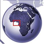
Geography
.............THE ARCHIPELAGO is constituted of two principal islands (called Concelhos ) of volcanic origin, São Tome (850 km²) and Príncipe (142 km²), as well as the small islands or surrounding islets of Cabras to the north, of Sete Pedras, of Santana and of Quixiba to the east, of Rolas to the south, renowned for its voador, flying fish and Gobaldo and Coconut to the west.
The archipelago covers a total area of 1 001 km². It is situated to some 350 km of the Gabonese coasts and the Equateur passes to 2 kilometers of Ponta Lamaporco, the point on island of Sao Tome, the separating island Rohas. The capital and principal lay country is the city of São Tome (53 300 inhabitants).
The principal island counts only a dozen towns, principally in the north of the island. The other importance city is Santo Antonio (1 200 inhabitants) in the island of Príncipe.
The distance separating the island of São Tome of the island of Príncipe is of 152 km. The peak point of the country is the Pico of São Tome (2 024 m). One notes equally the presence of two natural parks (conservation zones) of a total surface of 295 km², be 30% area of the archipelago.
This country is the smallest one of the Africa countries.
Some indicators:
• Total Area: 1.001 km² of which 864 for São.Tome
• Population: about 206.178 inhabitants of which 6.000 on the Principle island.
• Density to the km² : 206.
• Life Expectancy: 65 years.
• Growth Rates of the population: 2.2% /year.
• Principal production: cocoa.